NATIONAL AND KAPODISTRIAN UNIVERSITY OF ATHENSNATIONAL AND KAPODISTRIAN UNIVERSITY OF ATHENS
LABORATORY OF REMOTE SENSING

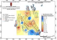
Research > GIS >
CEPHALLONIA

Cephallonia 
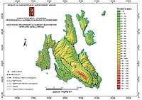
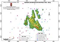
Island in the Ionian Sea is the most seismic active area in Greece. Large number of earthquakes (with magnitude M>6) has been recorded to the region. The last major earthquake (M=6.7) took place in 1983. Since then no other significant earthquakes (M>6) have been recorded.
The area studied within the framework of the multidisciplinary Research Project "Precursory seismic studies in the Broader Area of Cephallonia (Greece)". A large amount of heterogeneous information like: topography, geology, tectonic, morphotectonic, seismology, geodesy (GPS measurements) and satellite images, from different sources, in different format, scale and map projections has been compiled.

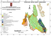
Layers in vector and raster format as well as thematic and synthetic maps (Maps 8-12) were produced in a common cartographic system (Hellenic Geodetic System 1987) and a GIS database was developed aiming to Earthquake Emergency Planning.

Shaded Relief of Cephallonia Island (resolution 20m) overlaid by tectonic data and the positions of GPS measurements:

600x424 jpg, 48 Kb
Map 8 (600x424 jpg, 48 Kb)

Earthquake Epicenters (M >=5) during 1900 – 2002:

600x424 jpg, 36 Kb
Map 9 (600x424 jpg, 36 Kb)

Geological Map of Cephallonia Island:

600x425 jpg, 47 Kb
Map 10 (600x425 jpg, 47 Kb)

3D Model of DinSAR of Cephallonia Island (Sept. 1995 – Aug. 1998) overlaid by tectonic data:

600x412 jpg, 80 Kb
Map 11 (600x412 jpg, 80 Kb)

Map of horizontal and vertical ground deformation of Cephallonia Island for the period 2001 – 2003:

600x424 jpg, 46 Kb
Map 12 (600x424 jpg, 46 Kb)


[GPS|DINSAR|Thermal Imaging|Optical Images|GIS|Digital Cartography]
[Personnel|Recent publications|Projects|Links]
[webmaster@space-unit.gr]
created by webmate.gr