LABORATORY OF REMOTE SENSING
|
Research > DIGITAL CARTOGRAPHY AND THE GEOSCIENCES
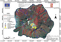
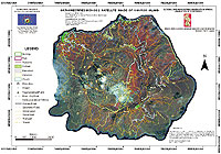
A map is a scale representation of a geographical environment. The purpose of a map is to provide a meaningful picture of reality. A map, therefore, can be a particularly useful guide in the orientation of terrain, as well as conveying other multi-faceted information through supplementary annotations. The map is the basic feature for numerous applicationsin the Geosciences: Geology, Tectonics, Geophysics, Seismology, Geothermics, Geomorphology, Geochemistry, Volcanology, Marine Sciences, etc. Digital Cartography involves the creation and analyses of maps through the use of computers. As such, Geographical Information Systems (GIS) are an integral tool for Cartography. Various Thematic and Ortho-photo Maps (using the Arc/Info and ArcView GIS software packages) were created, following the demands of Cartography (e.g. scale, generalization, map projections) in the Space Applications Research Unit during the last few years (see also GIS 0n this site).
REFERENCES:
Lagios, E., Dietrich, V., Stavrakakis, G., Parcharides, I., Sakkas V., Vassilopoulou Sp. (2001). Will Nisyros Volcano (GR) Become Active? Seismic Unrest and Crustal Deformation. European Geologist, 12, 44-50. Vassilopoulou,
S., Hurni, L., Dietrich, V., Baltsavias, M., Pateraki, M., Lagios,
E.,Parcharidis, Is. (2002): Ortho-Photo Generation using IKONOS-2
Imagery and High Resolution DEM: A Case Study on Monitoring the
Volcanic Hazard on Nissyros Island (Greece), ISPRS Journal of
Photogrammetry and Remote Sensing, 57, 24-38.
|
|
[GPS|DINSAR|Thermal Imaging|Optical
Images|GIS|Digital Cartography]
[Personnel|Recent publications|Projects|Links] [webmaster@space-unit.gr] |