LABORATORY OF REMOTE SENSING
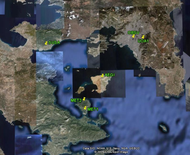
| Research > GPS > Saronikos Gulf (1174x966 jpg, 76 Kb) The NW
Hellenic
volcanic arc consists of the Plio-Pleistocene volcanic centers of
Susaki, The
kinematic pattern of the
NW volcanic arc was studied by DGPS measurements, for the period
2006-2008
(Papageorgiou PhD Thesis). The GPS network was established and firstly
measured
in 2006, while two more measurements were carried out, in 2007 and
2008. The
network was comprised of five (5) stations, the two of them placed at
Methana
(MET1 & 2) and each one of the rest in Aegina (AEGI), Susaki (SUSA)
and
Athens (UOA1). During the measurements an extra site (OBSV) was
occupied,
located in Geodynamic Institute of NOA. The results reveal significant
deformation
features underlying the partition of the two basins of
REFERENCE:
Papageorgiou E.
& Lagios E. 2009. Crustal movements along the NW
Hellenic volcanic arc from DGPS measurments. Bulletin of the Geological
Society
of Greece (submitted). |
| [GPS|DINSAR|Thermal Imaging|Optical
Images|GIS|Digital
Cartography] [Personnel|Recent publications|Projects|Links] [webmaster@space-unit.gr] |