LABORATORY OF REMOTE SENSING
|
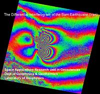
Research > DiNSAR > Bam (IRAN) earthquake DIFFERENTIAL INTERFEROGRAM OF THE BAM (IRAN) EARTHQUAKE (Ms=6.5) IN DEC. 26, 2003 Three ENVISAT ASAR images were used dated Dec. 3, 2003, Jan. 7, 2004 and Feb. 11, 2004 (data source: European Space Agency). The Atlantis EVInSAR v.3.1 s/w was used following the three-pass interferometric method. The first two images (Bp=570m) were used to create the DEM (step 1), and the first and third image (Bp=0.6m) to create the differential interferogram, using the generated DEM as an input external DEM. The coherence image showing good coherence for most of the area covered by the ENVISAT Image
|
|
[GPS|DINSAR|Thermal Imaging|Optical
Images|GIS|Digital
Cartography]
[Personnel|Recent publications|Projects|Links] [webmaster@space-unit.gr] |