LABORATORY OF REMOTE SENSING
|
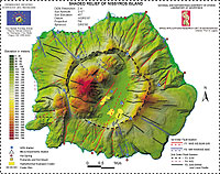
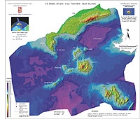
Research > GIS > Monitoring of Volcanic Activity (Kos – Yiali - Nisyros) The islands of Nisyros, Yiali, Kos, Santorini, Milos, Poros, Aegina and the Peninsula of Methana constitute the Hellenic Volcanic Arc. The eastern sector of the arc, including the islands of Kos, Yiali and Nisyros seems to be geodynamically very active since it comprises the largest volumes of volcanic products and is at present a region of high tectonic unrest. Active volcanoes represent several natural hazards for populated regions. These hazards often occur as combinations of earthquakes, gas-explosions and hydrothermal eruptions, volcanic eruptions, landslides, mudflows, tsunamis etc. For that the research project GEOWARN (IST 1999-12310) financed by the European Union has been established. The objectives of this scientific study are to conduct an integrated informative, volcanological, geophysical and geochemical project to assess volcanic and seismic hazards related in the most active part of the Eastern Mediterranean by the help of a GIS database, as well as an integrated geo-spatial multimedia system for the region. The use of a Digital Elevation Model (DEM) is important for any geo-environmental study. A selection of DEMs in different scales with various resolutions for Kos - Yiali - Nisyros - Tilos islands was produced. The DEMs will serve as the base for thematic applications, as well as the base for production of a great variety of maps.
REFERENCES:
Lagios, E., Dietrich, V., Stavrakakis, G., Parcharidis, I., Sakkas, V., Vassilopoulou, Sp. (2001): Will Nisyros Volcano (GR) Become Active? Seismic Unrest and Crustal Deformation. European Geologist, 12, 44-50. Lagios, E., Dietrich, V., Stavrakakis, G., Parcharides, I., Sakkas V., Vassilopoulou Sp. (2001). Crustal Deformation in the Kos-Yiali-Nisyros Volcanic Field after the 1996/97 Seismic Crisis. Terra Nova (submitted). Vassilopoulou,
S., Hurni, L. (2001): The Use of Digital Elevation Models in Emergency
and Socio-Economic Planning: A Case Study at Kos – Yali – Nisyros -
Tilos Islands, Greece. Proc. 20th International Cartographic
Conference, August 6-10, Beijing, China.
|
|
[GPS|DINSAR|Thermal Imaging|Optical
Images|GIS|Digital
Cartography]
[Personnel|Recent publications|Projects|Links] [webmaster@space-unit.gr] |