LABORATORY OF REMOTE SENSING
|
Research > Satellite Thermal Imanging > Image Processing of ASTER Data The ASTER Sensor ASTER is the acronym for Advanced Spaceborne Thermal Emission and Reflection Radiometer. It is a Japanese multispectral sensor carried on the TERRA satellite, which was launched on December 18, 1999. TERRA orbits the Earth with a period of 98.1 minutes at a height of 720 km. The instrument is described at the following web site: http://asterweb.jpl.nasa.gov/instrument/instrument.htm. ASTER is a narrow-field of view sensor (the swath angle of the sensor is ±2.4°), which scans a swath of 60 km on the ground every 16 days. The sensor has nine (9) reflective bands and five (5) bands in the thermal infrared, providing thus a wealth of spectral information to map geological surfaces. In the TIR region, ASTER has 12-bit quantization, a radiometric precision (NEDT) of 0.3 °K, and one standard deviation calibration uncertainty of 1 °K between 270-340 °K. The ASTER level 1B scenes of Nisyros are registered radiance at sensor products, produced by the Japanese Ground Segment and delivered by EROS Data Centre in HDF format. The thermal infrared telescope operates in "whiskbroom" mode and collects emittance with a 90 m spatial resolution. Data
Processing
The ASTER data were imported into GeomaticaTM v8.2.1 as 16-bit unsigned integers. The data were first processed using ATCOR2 assuming a constant emissivity value of 0.98. We assumed a visibility of 15 km for all passes based on the meteorological data supplied to us by the Hellenic Meteorological Service (EMY). These data (Air Temperature, Dew Point, Relative Humidity, Atmospheric Pressure) were collected at the Kos and Rhodes airports, every hour, at distances 25 and 80 km, respectively. TERRA passed over Nisyros at 09:11:55 GMT on April 26, 2002 (local time 12:11:55) and at 20:15:08 GMT on June 13, 2002 (local time 23:15:08). The
ATCOR2 processing results are as in the following:
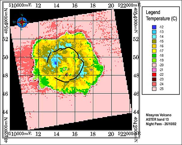
Figure 1: Colour overview of the processed ASTER scene of the Nissyros volcano acquired on 26 October 2002 GMT. A smooth colour pattern blue-green-red-purple corresponding to cold-medium-hot temperatures is shown. White line indicates the coastline and broken black line indicates the caldera rim. The Stefanos crater rim is indicated by the small black circle in the south of the caldera. Note the thermal anomaly (22-23 °C) inside the crater. Grid is UTM35.
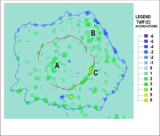
The ATCOR3 (Topographic Influence) This work is arranged in three steps. In step A, the ATCOR3 software produced the topographically corrected temperature image of the volcano. The ASTER day scene (April 26, 2002) was orthorectified using the OrthoEngineTM software package. The orthorectified image was then imported to the ATCOR3 software. The algorithm removes the topographic effects using a DTM to obtain information about surface elevation, slope and aspect. A US standard atmospheric model was used together with 15 km visibility. In step B, the co-registration of images takes place. To be able to compute the relative temperature difference per pixel for the April 26, 2002 scene, the ATCOR2 image was geo-referenced to the ATCOR3 image by the use of a 1st order polynomial transformation. Then mean the error of registration was less than 1 pixel. In step C, the two images are subtracted in the following order: ATCOR3 image - ATCOR2 image (Fig. 2). Finally, a low pass, 3x3 filter is applied to remove outliers. Although the mean difference is close to 0 °C, large differences exist on both ends of the histogram. This suggests that large differences are associated with steep topography. Figure 2: ATCOR difference image of Nissyros volcano during the ASTER day overpass on the 26-4-2002. Areas with large positive temperature differences (> 2 °C) are located on the western part of the caldera (area A), on the northeast part of the volcano (area B) and along the caldera rim (area C).
Conclusions The results show a good comparison with previously processed LANDSAT7 ETM+ thermal data (Ganas & Lagios, 2003). The overall agreement of these results with previous campaigns in Nissyros, includes the mapping of the "orographic effect" (Fig. 1), so as it is proposed that ASTER data may be successfully used to monitor the thermal status of the volcano. In addition, the comparison of the ASTER thermal map for October 2002 to the LANDSAT7 thermal map for October 2000 (Ganas & Lagios, 2003) show that surface temperatures inside Stefanos Crater have risen on average by 2 °C within the period 2000-2002. The method of image differencing to investigate the topographic influence in our day processing results was also used. The computed temperature differences indicate that
REFERENCES:
|
|
[GPS|DINSAR|Thermal Imaging|Optical
Images|GIS|Digital
Cartography]
[Personnel|Recent publications|Projects|Links] [webmaster@space-unit.gr] |